The outcome of the Civil War was influenced by many factors on both sides, including population, finances, the availability of weaponry, naval power and military leadership.
But in a recent study published by the Geological Society of America, a North Carolina professor suggests a less obvious factor: rocks.
“It is not an overstatement to say that rocks helped determine the outcome of the Civil War,” said Scott Hippensteel, an associate professor in the Department of Geography and Earth Sciences at the University of North Carolina at Charlotte. “Geology determines terrain, and terrain can be exploited by a skilled commander on both offense and defense.”
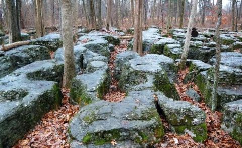
The karrens that supported the Union defensive line at Stones River. Union soldiers were to abandon this position after hours of fighting because of a lack of ammunition. Scott Hippensteel
Hippensteel’s study, “Carbonate rocks and American Civil War infantry tactics,” provides specific examples of geology’s role throughout the war.
“Overall, the geology didn’t favor either side,” he said. “Nevertheless, multiple individual battles were strongly influenced by the geology of the region, and the geology seemed to favor whichever side took a more defensive approach.”
Carbonate rocks, named for the minerals involved in their composition, are sedimentary rocks consisting of two major types: limestone and dolostone. Limestone is a soft rock that’s easily scratched. Dolostone – also called dolomite to reference its mineral composition – is similar to limestone but harder and heavier.
Hippensteel said the most significant factor with respect to hardness isn’t whether a rock was limestone or dolostone but what other materials were included or interbedded in the carbonate rock. For example, there are several examples of rocks that contain chert (microcrystalline silica).
“Chert is really hard and would have made the carbonate rock more difficult to weather and erode,” he said. “The result would be a good defensive ridge, like the Snodgrass Hill and Missionary Ridge area in the Chickamauga and Chattanooga region.”
Part of Hippensteel’s analysis examined a mix of the harder diabase (dark-colored igneous rock) and softer sedimentary rocks, which produced famous Civil War landscape features such as Cemetery Hill and Little Round Top.
Those features proved to be key defensive strongholds for the Union at the pivotal Battle of Gettysburg. Cemetery Hill, Little Round Top and Seminary Hill, which was used by the Confederates at Gettysburg as a staging area for assaults on Union positions, were all underlain by diabase, Hippensteel notes.
“This harder rock formed hills, and the outcropping boulders could be used for breastworks – temporarily constructed fortifications, usually about
Between these two hills, Hippensteel notes, is softer sedimentary rocks that formed the broad, gently sloping plain over which Confederate Gen. Robert E. Lee launched the ill-fated “Pickett’s Charge.”
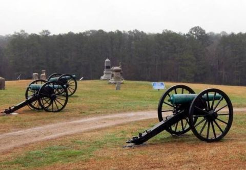
Union 12-pounder “Napoleon” cannons on Snodgrass Hill, Chickamauga. They made a stand at Snodgrass Hill after its line had been broken earlier in the day. Scott Hippensteel
Lee’s attack left one high ridge of hard igneous rock, traveled across softer sedimentary rock, and attacked another high ridge of igneous rock. This jumble of terrain contributed to the Confederates’ struggles at Cemetery Ridge.
Of course, the Union and Confederate armies couldn’t always prioritize or dictate terrain in the face of rapidly changing events and conditions.
Hippensteel said the ideal rock type from an offensive standpoint would probably have been limestone, which was found on many portions of the Stones River battlefield – one of the war’s bloodiest conflicts, in middle Tennessee.
“The limestone is found just below the surface, which prohibits tillage or farming,” he said. “The result was a terrain that was forested – good for concealment of attacking troops – and made digging trenches or creating fortifications more difficult.”
For defensive positions, Hippensteel said the ideal choice would depend on the geographical scale of the fighting. For small scale fighting, the karrens at the center of the Union line at Stones River would have been advantageous.
“These are basically limestone trenches deep enough to conceal a kneeling soldier,” he said.
On a larger scale, Hippensteel said the diabase ridges of Gettysburg, which are difficult to climb, would likely have been ideal.
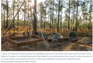
More than 150 years after Lee’s surrender at Appomattox Courthouse, researchers and historians are uncovering new information about the war.
“Geoarchaeologists are developing and using all kinds of new, non-invasive technology to study battlefields,” Hippensteel said.
As an example, he cited 3-D computer modeling of battlegrounds that is giving new perspectives on what soldiers could actually see from different positions on the battlefield.
He predicts that the use of light detection and ranging, via a laser light, will allow better mapping of Civil War fortifications in the future.
–thestate.com